Topographic surveys (or topo surveys) are a crucial part of site planning, providing project managers with valuable insights about a terrain before any physical development begins. However, gaining an in-depth visual on the entire site can provide its challenges, such as limited accessibility, requiring an alternative solution - unmanned aerial vehicles (UAVs).
This article will assess the success of drone-based topographic surveys across several industries, helping you to understand why they’re used and how your business could benefit from one.
What Is a Topographic Survey?
Topographic surveying is a detailed mapping process that captures the natural and man-made features of a land area, including elevations, contours, and structures. This helps site developers to gain a complete understanding of how land looks, and whether it is suitable for construction.
How Do Drone Topographic Surveys Work?

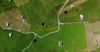
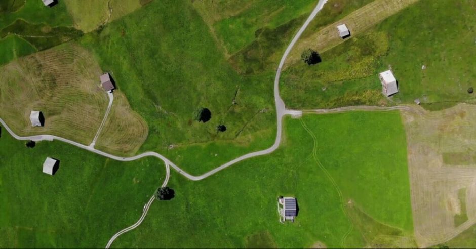
Professional drones - equipped with 4K high-definition cameras - capture aerial imagery of your site by flying over a pre-determined survey area, collecting overlapping photographs from multiple angles. These images are processed using photogrammetry software, which stitches them together to create accurate 2D and 3D representations of the terrain.
In contrast, traditional land surveying relies on total stations, GPS receivers, and ground-based measurements to collect elevation and coordinate data. While this can be highly accurate, this process is labour-intensive and time-consuming, especially for large sites or inaccessible areas. Drones eliminate these issues by covering large areas quickly and precisely, reducing disruptions to the surrounding environment.
Common Applications of Topographical Drone Surveys

Drone-based topographic surveys are widely used around the world, spanning many different industries. The most common examples include:
- Construction & Urban Planning: Drones enable the tracking of construction projects, helping site managers identify potential issues early and maintain project timelines.
- Environmental & Agricultural Monitoring: Detailed images help farmers assess crop health and improve irrigation strategies, leading to more sustainable land management.
- Mining & Quarrying: Drone surveys generate accurate 3D models of mining sites, helping operators calculate stockpile volumes and monitor resource extraction.
- Land & Property Development: High-resolution imagery provides developers with precise information on existing land features - crucial for planning layouts and drainage systems.
Data Outputs from Drone Topographic Surveys
Drones can provide a range of data outputs that are essential for land planning, construction, agriculture, and environmental monitoring. These include:

2d Orthomosaic Mapping

2d Photogrammetry

3d Digital Models
Here at Full View, we can offer data outputs in whatever format you need, from a 2D Orthomosaic to a 3D Digital Twin. If you would like to see an example drone topographical survey before you work with a drone surveying partner, then get in touch. We are happy to provide you with an example report of some of our previous work.
Essential Components of a Topographic Survey
A topographic survey is composed of several key elements that together provide a comprehensive view of a site’s terrain and features. Here are the essential components that are assessed:
Survey Control Points
These are fixed reference markers established throughout the survey area. They ensure that all data is accurately aligned with geographic coordinates, providing a consistent framework for measurements. Control points are important for maintaining survey accuracy and for integrating multiple datasets.
Elevation Data
Elevation data captures the vertical position of the ground at numerous points across the area. This data is essential for understanding the land’s relief, forming the basis for digital elevation models (DEMs), and calculating slopes and gradients that influence water drainage, construction, and environmental planning.
Contour Lines
Derived from elevation data, contour lines connect points of equal elevation across a site. They visually represent the terrain's shape, making it easier to identify gradients, hills, valleys, and ridges. This information is crucial for planning construction projects, managing water flow, and understanding potential risks (such as erosion).
Natural Features
These include natural elements such as trees, bodies of water, rock formations, and dense vegetation. Recording natural features provides insight into the existing environmental conditions, which can impact construction, conservation efforts, and land management strategies.
Man-Made Features
This covers all human-made structures, from buildings to roads, bridges to power lines. By including man-made features in the topographic survey, the current infrastructure can be accurately mapped, which is vital for planning new developments, updating maps, or integrating change into existing systems.
Key Benefits of Using Drones for Topographic Surveys
There are many benefits to using a drone for topographic surveys, such as:
- Improved Safety: Drones reduce the need for staff to access potentially unstable or dangerous terrains and environments, improving health & safety.
- Reduced Risk: By assessing an entire site, drones can inform developers about the potential risks within the terrain before a project begins.
- Increased Efficiency: Drones can scan a huge plot of land faster than any human could, quickly providing key insights for decision-making.
- Greater Accuracy: By using outputs like 3D digital twins, surveyors can form detailed, scalable models of the area, helping to reduce project planning errors.
- Stronger Land Tracking: Drones can revisit flight paths over several weeks, months, or even years, helping to track how the land develops over time.
Choosing a Drone Survey Provider
Now that you understand what a drone-based topographical survey is, you’ll need to find yourself a qualified pilot to conduct the survey. Your chosen pilot must hold a CAA (Civil Aviation Authority) license, and should ideally have extensive experience in topographical surveys - proving they really know what they’re looking for.
To assess the suitability of your drone pilot, there are several questions to ask. These could include:
- Do you have insurance coverage for drone operations? What does it include?
- Have you worked on similar projects before? Can you provide examples or references?
- What software do you use for data processing and analysis?
- What formats will the data be provided in? (e.g. orthomosaics, 3D models, raw images)
- How long will it take to process and deliver the final results?
- What is your pricing structure? Are there any additional costs for post-processing?
Explore Our Efficient Drone Mapping Services
If you’re looking for a drone pilot who is efficient and experienced in drone mapping, look no further than Full View. Our team offers quality, precise digital mapping of your land to help you make the most informed decisions and complete projects with greater accuracy.
To get started with us, simply contact us online for an initial consultation, where you can ask as many questions as you need about how we work and what’s involved!