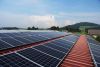
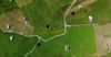
For industries such as construction and agriculture, measuring the volume of your stockpiles is an important, but difficult task. However, the use of drones is becoming an increasingly popular, cost-effective, and efficient method of gaining accurate stockpile measurements. This article will assess how drones - often known simply as UAVs - achieve this task, and how your business can benefit from drone stockpile surveys for stronger day-to-day operations!
What Is a Stockpile Measurement, and Why Is It Important?
A stockpile measurement survey determines the volume, size, or weight of stored materials such as gravel, coal, or sand using surveying techniques. It is important for accurate inventory management, cost control, compliance with regulations, and efficient resource planning across a huge range of industries.
How Do Drone Stockpile Measurements Work?

To gain accurate stockpile measurements, drones use aerial surveying technology to capture a series of high-resolution images and generate 3D models of a stockpile. The drone, manned by a qualified pilot, will fly over the defined target area, capturing images from multiple angles. These images are then processed using specialised software to generate precise 3D models and digital surface maps.
Photogrammetry for Accurate Volumetric Calculations

Photogrammetry is a process used across many different drone-based tasks, which extracts spatial data from 2D images to reconstruct a 3D model. They’re particularly useful for stockpile measurements, allowing businesses to accurately track inventory levels and optimise material usage:
- The drone captures overlapping photographs of the stockpile from different perspectives.
- These images are processed using photogrammetry software to create a georeferenced 3D point cloud.
- The software calculates the stockpile’s volume by comparing the surface model to a predefined base level.
What Industries Use Stockpile Measurements?
Stockpile measurements are a regular task for many industries, such as:

Mining
- To estimate the quantity of quarried materials available for processing.
- To assess stockpile composition and quality, such as the grade of mined minerals.

Recycling
- To measure volumes of scrap metal, paper, or plastics in stockpiles.
- To determine how much material is ready for sorting or processing.

Shipping Centres
- To calculate the volume of goods in storage, such as bulk products or containers.
- To ensure accurate stock levels for dispatch and optimise the organisation of storage.

Construction Sites
- To measure and estimate the volume of materials like gravel, sand, or cement.
- To track material usage and monitor the productivity of a construction site.

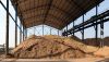
Agriculture
- To measure the volume of harvested crops in silos or fields.
- To calculate the stock of fertilisers, pesticides, and feed for livestock.

Manufacturing
- To ensure raw material stock levels are sufficient for uninterrupted production.
- To calculate the quantity of finished products in warehouses for stronger supply chain management.
Benefits of Using Drones for Stockpile Measurements
Drones offer a whole host of different benefits when it comes to measuring stockpiles, including:
- Improved accuracy and reduced human error.
- Faster data collection compared to manual volumetric surveys.
- Cost savings on labour and equipment.
- Increased workplace safety by reducing the need for on-ground staff.
- Gives you useful information for more informed decisions.
- Helps you stay compliant with regulations such as the EU Emissions Trading System, where businesses are required to do a mass balance to calculate CO2 emissions (more accurate stockpile measurements make this easier to calculate).
Measuring Stockpiles Using Drones: A 5-Step Process

The process for a stockpile drone survey is very simple; although every drone operator works in a slightly different way, there’s a rough process outline which most follow:
1. Selecting the Right Drone Surveyor and Discussing Needs
Start by choosing a qualified drone operator with experience in stockpile surveying. They should hold a UK CAA (Civil Aviation Authority) licence for drone-based operations. Once you’ve arranged a consultation, the drone pilot will discuss factors such as your location, requirements, and reporting formats (such as 3D models).
2. Planning the Flight Path Using Drone Software
Efficient flight planning is crucial for capturing comprehensive data; your drone pilot will define the survey area, set flight parameters, and configure image overlap settings for optimal digital coverage and 3D modelling. Many people who use a stockpile measurement service often have multiple stockpiles or sites, so different flight paths will need to be planned in these cases.
3. Capturing Aerial Images with Proper Overlap and Altitude
The drone will autonomously follow the pre-planned flight path while capturing multiple images from various angles; this helps the size, measurement and volume of the stockpile to be determined. Settings will be adjusted based on the size of the stockpile, the terrain of the area, and the weather conditions on the day of the flight.
4. Processing Data Using Photogrammetry Software
Once the images are captured, they are processed using photogrammetry software to generate a 3D model. This involves:
- Stitching images together to create an orthomosaic map and digital elevation model (DEM).
- Aligning images with reference points for geospatial accuracy.
- Producing a 3D point cloud representing the stockpile’s shape and volume.
5. Calculating Stockpile Volume and Presenting Results for Analysis
The output software will compare the 3D stockpile model against a predefined base level, and the volume is calculated using advanced algorithms which consider slopes and irregularities. Reports are generated based on the survey’s findings, providing insights such as total volume, estimates of material density, and inventory tracking.
Leave Stockpile Measurements to the Professionals
If your business handles commodity stockpiles and needs them to be frequently measured, don’t waste time doing it the “old-fashioned” way. Our drone pilots can ensure your stockpile is measured much faster and more precisely than any manual method!
Getting started with us couldn’t be easier - simply get in touch with us today to discuss your needs, and we’ll find a convenient time to assess your site and measure your stockpiles, helping you to make smarter, more informed business decisions over your inventory.