If you’re a site manager or project planner, then you likely face a range of challenges when monitoring construction site progress: From ensuring targets are met to maintaining safety standards. Traditional methods such as manual inspections and on-site photography - are often time-consuming and prone to human error, making it difficult to ensure projects are on track.
However, technological advancements have revolutionised construction tracking - ditch the seemingly endless Excel spreadsheets, as we’ve got something much more effective for the job…
Drones and 3D modelling software offer a more efficient and accurate way to monitor every aspect of the project. In this article, we’ll explore how to effectively track construction progress, the benefits of using a drone to achieve this, and how to find the best drone surveyor to handle the task!
What Common Tasks Do Site Managers Handle?

Although every construction project is different, there are several common roles that site managers are tasked with, such as:
- Timeframe Adherence: Measuring task progress against deadlines.
- Resource Management: Allocating material, equipment, and labour efficiently.
- Budget Oversight: Managing material and labour costs to prevent overspending.
- Quality Assurance: Ensuring quality standards and specifications are met.
- Safety Checks: Maintaining a safe working environment on-site.
- Team Coordination: Communicating with contractors and engineers.
- Problem-Solving: Addressing unexpected delays, material shortages, or other issues.
Traditional Methods vs. Drone Technology

Traditional methods for monitoring a site involve a “boots on the ground” approach, where project managers get a first-hand view of the construction progress.
- Photographs and videos are captured by the project manager or a designated inspector as they walk around the site, which, understandably, is rather time-consuming - especially for larger areas.
- Humans are also prone to errors, which could affect the data collected, and certain areas may be impossible to safely reach.
Using Unmanned Aerial Vehicles (UAVs) for construction progress tracking offers a much more efficient solution.
- These drones, manned by a pilot on-site, are flown around the site to photograph and record all areas of the construction plot, including the hardest-to-reach angles and heights.
- This inclusive aerial view provides more accurate insights into the current state of the site, leading to more informed decisions.
- The repeatability of drone flights enables consistent data collection over time, which is crucial for monitoring changes throughout a project's lifecycle
Can Drones Replace Human-Led Construction Monitoring?
Although drones have proven to be a game-changer for the construction industry, it’s highly unlikely they’ll ever completely replace human-led construction monitoring. Instead, the best approach will be to use drones as a tool to aid the process, not handle it entirely.
For example, several aspects of construction monitoring still benefit from the “human touch”, such as on-site decision-making, material quality assurance, and ground-level safety insights. Drones can be used to automate the most repetitive parts of the process, such as regular site surveys, freeing up staff to focus on the strategic sides of construction tracking.
How Do Drones Aid in Tracking Construction Progress?

Drones are capable of handling several tasks during construction site monitoring, including:
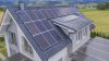
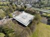
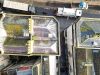
Aerial Imaging & Video
- Capturing high-resolution images and videos for a complete site overview.
- Monitoring progress from multiple angles, identifying potential issues early on.
- Providing valuable visual updates to project managers and stakeholders.
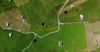
3D Modelling & Mapping
- Generating detailed 3D digital twins and topographical maps of the construction site.
- Enabling visualisation of progress, and comparisons between planned and actual work.
- Helping detect discrepancies, design flaws, or potentially problematic areas.
Inventory Management
- Tracking the location and usage of equipment and materials.
- Reducing the risk of misplacing or over-ordering resources.
- Maintaining accurate records for budgeting and planning purposes.
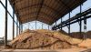
Stockpile Surveys
- Performing volumetric analysis of stockpiles to estimate material quantities on-site.
- Saving time and improving accuracy, compared to manual measurements.
- Supporting better resource allocation and reducing wasted materials.
Timelapse Videos
- Creating engaging timelapse videos to showcase the progress to stakeholders.
- Maintaining trust and transparency by visually demonstrating progress.
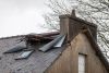
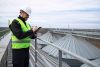
Safety Inspections
- Identifying hazardous areas or unsafe practices without putting anyone at risk.
- Monitoring compliance with health & safety regulations and site standards.
What Are the Benefits of Drone Surveys for Construction?
As mentioned throughout, drones offer a huge range of benefits for construction sites, such as:
- Full Site Coverage: Drones capture high-resolution aerial images and videos, providing a full view of the construction site that traditional methods cannot achieve.
- Improved Accuracy: The drone’s sensors and GPS enable precise measurements for site mapping, volumetric surveys, and tracking structural progress.
- Time Efficiency: Drones can scan large areas at high speeds compared to humans, and collected data is quickly compiled into easy-to-read progress reports.
- Cost Savings: Reduces the need for expensive equipment, scaffolding, or manual labour for inspections and measurements.
- Greater Safety: Drones can access hazardous or hard-to-reach areas, such as rooftops or unstable terrain, without putting workers at risk.
- Improved Reporting: High-quality visual data improves site documentation and simplifies progress reporting for relevant staff.
What Are the Challenges of Drone Surveys for Construction?
Although drones are beneficial on the whole, there are a few challenges to be aware of:
- Weather Considerations: Drones cannot be flown in certain conditions, such as heavy rain or wind. However, this can affect any construction progress monitoring!
- Restricted Areas: Not all areas are permitted for drone usage, requiring the need for special clearance, such as near military or government buildings.
- Operator Quality: Finding an experienced drone operator isn’t always easy; look for one that offers a proven track record in construction monitoring, such as Full View.
5 Steps to Implement Drone Surveys for Construction Progress

Using drones for construction monitoring requires a structured approach to ensure the best results. Follow these steps to smoothly integrate drone surveys into your construction project:
1. Define Progress-Tracking Objectives
Start by identifying what aspects of your project progress need to be monitored, such as site safety or material usage. This will help you establish clear goals and track progress against your projected timeline. You should also determine the key metrics or data you’ll need from the surveys to make the most informed decisions.
2. Choose the Right Drone Surveyor
Partner with a professional drone survey service, like Full View, with expertise in construction monitoring. Enquire about any advanced drone services you’d like to benefit from, such as 3D mapping or volumetric analyses, as not all operators offer these!
3. Plan Regular Survey Schedules
Establish a consistent survey schedule to monitor progress at key stages of construction, aligning these with certain milestones to track specific objectives. It’s important to account for poor weather conditions and site accessibility when you schedule upcoming drone flights, although we appreciate that the weather can be unpredictable!
4. Receive Survey Results and Share Insights
Once you’ve been provided with your report, review the survey data to identify discrepancies, track progress, and detect any potential issues on your site. These results should be easy to read, meaning they can be shared with contractors, stakeholders, and other relevant staff.
5. Use Findings to Adjust Timelines, Budgets, or Resources
Using the data from the drone survey, adjust your project plan accordingly, such as by reallocating resources or revising schedules. Your report should allow for more informed decisions to be made, which may reduce bottlenecks and other delays!
What to Look for When Choosing a Drone Surveyor

Putting it simply, there are three main things you should prioritise when looking for a suitable drone surveyor:
- Expertise: How knowledgeable is the surveyor? Do they know what to look for?
- Reliability: Could you rely on them to regularly conduct construction surveys?
- Flexibility: Will they be flexible for your needs? Could they visit your site often?
To ensure you’re getting the best service for your money, it’s important to ask as many relevant questions as you can before getting started. You should check if the surveyor offers services such as 2D orthomosaic mapping, timelapse videos, or 3D digital models; these give you a better account of the construction area, as well as demonstrate the expertise of the operator.
It’s also important to choose a surveyor who is willing to adapt to your project’s needs. For example, if you’re managing multiple sites across London, Berkshire, and Oxfordshire, you’ll want someone who is not only skilled in delivering precise data but is also happy to travel to conduct surveys!
Contact Us Today for Accurate Site Progress Monitoring
If you’re looking for a drone operator who is reliable, flexible and demonstrates expertise, look no further than Full View. Our team are experienced in construction progress monitoring, combining deep knowledge and practical solutions to provide you with a set of actionable results.
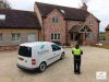
Based in the heart of Oxfordshire, we’re not afraid to travel to your construction site for regular surveys, even if you have several locations further afield. Simply contact us today to ask any questions you may have, or schedule a FREE consultation so we can assess your needs