Drone Thermal Imaging Surveys & Inspections
Save time, reduce costs, and gain unparalleled insight into your property’s performance with our professional thermal drone surveys.
At Full View, we combine state-of-the-art DJI drones and high-definition thermal sensors to identify problems you can’t see – from heat loss and air leakage to damp, insulation gaps, or electrical faults. Whether you manage a commercial property, solar farm, or residential home, our experienced, CAA-certified pilots deliver fast, safe, and detailed results – usually within just 72 hours.
About Our Drone Thermal Imaging Services
Our drones use advanced thermal imaging technology to provide you with an unparalleled inspection of your property, detecting issues invisible to the naked eye. We’re able to inspect roofs, confined spaces, and elevated areas quickly and safely – without scaffolding, ladders, or shutting down operations. That means no disruption to your home life or business, lower inspection costs, and a far faster turnaround for actionable results.
For residential customers, our thermographic surveys can identify anything from areas of heat loss to damp and structural weak points. This can be essential for maintaining the integrity of your home and reducing expensive energy costs.
For commercial properties, thermal imaging is useful for monitoring electrical hotspots and outputs over time, steam leaks in factories, and highlighting mechanical wear. They can also be essential for complying with the terms of your insurance.
Why Choose a Thermal Drone Survey?
Our advanced drones, fitted with thermal imaging cameras, offer distinct advantages over traditional manual, non-thermal drone surveys, including:
Faster Than Traditional Surveys
Traditional thermographic surveys can be time-consuming and offer a limited view of your property. Using drones equipped with the latest thermal imaging technology, we can offer a significantly faster service that gives you a complete view of the property or properties.
Save on Costs
Because our thermal drone inspections are much faster, we charge a lot less than traditional surveys. We also eliminate the additional costs required for any safety gear and scaffolding.
Find Issues You Can’t See
Our drones can give you a more comprehensive view by exposing issues and problems that are invisible to even 4K, high-definition cameras, such as air leaks under surfaces, insulation issues, and electrical hotspots.
Reduce the Risk of Damage
Minimises the risk of damage to your roof, property, or solar panels by reducing the need for on-site personnel. For commercial properties, this creates a safer environment for employees and prevents business disruptions. For residential properties, it reduces the risk of damage to your home.
High-Quality Images and Video
Our high-resolution thermal cameras capture images and video with far greater clarity than traditional surveys. We can deliver this visual data in multiple formats, tailored to your requirements.
Comprehensive Drone Report
We don’t just provide images and videos as part of our drone reports. You also get our expert analysis, as we identify and highlight issues and problems, making it easy for you to provide to contractors or insurance to get issues solved quickly.
Our Clients


Our Easy-to-Read Thermal Imaging Survey Reports
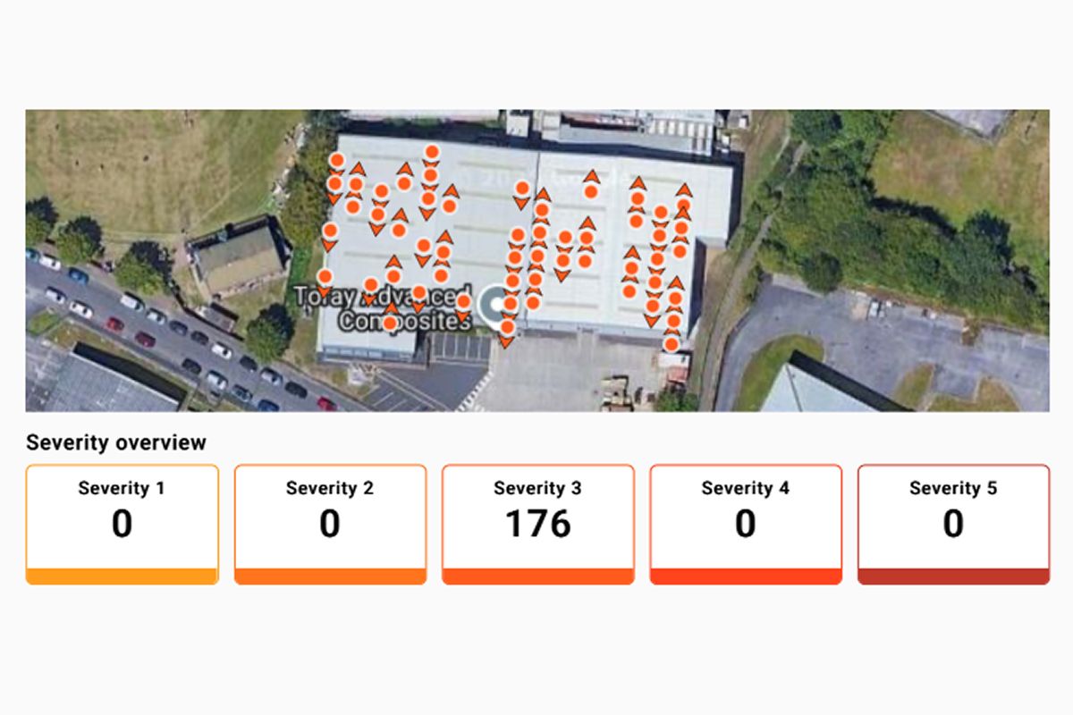
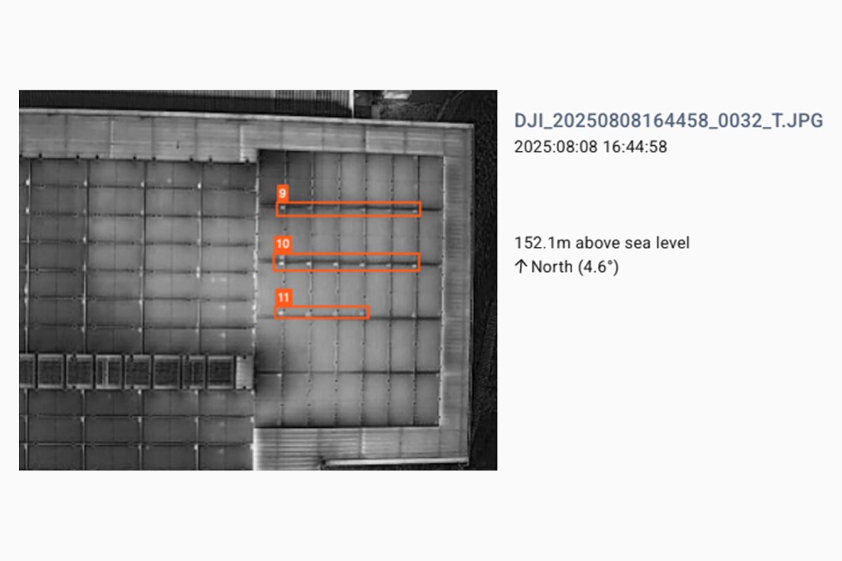
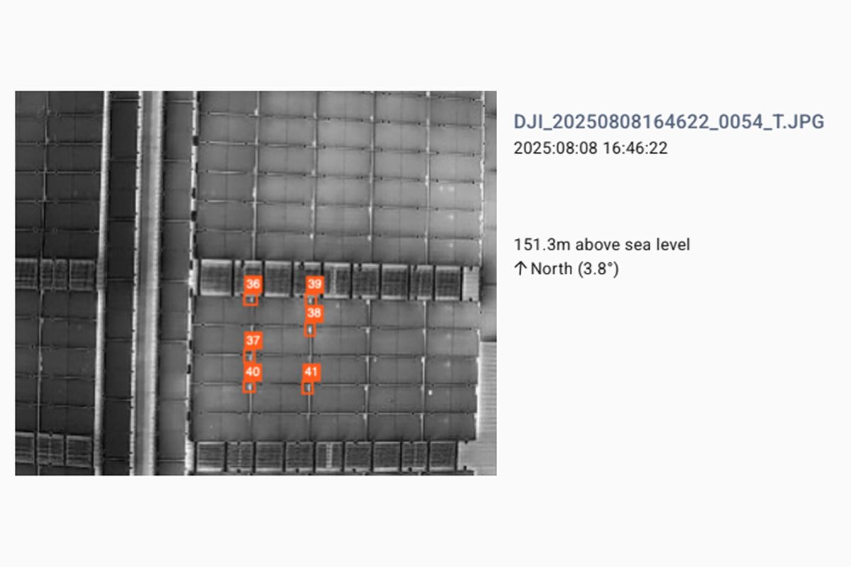
We make sure our thermal drone survey reports are easy-to-understand and accurate. You can see an example of our thermal drone inspection survey below for a commercial building's solar panels.
The DJI Matrice 4T Thermal Drone – Full Infrared Coverage
By using the DJI Matrice 4T, we can gain fast, field-proven thermal data that’s precise enough to act on – whether that’s finding a failing solar cell, an overheating electrical junction, or hidden heat loss from a roof.
The drone’s thermal sensor captures clear infrared images and video, lets us measure temperatures on the spot, and supports an infrared high-resolution mode (up to 1280 × 1024) for close-up analysis – so our reports point to the exact problem and the exact location to fix.
What Our Thermal Drone Surveys Look For
Unlike traditional manual inspections, which often require scaffolding or costly safety equipment and still may miss key areas, our thermal drone surveys capture every angle of your property, ensuring nothing is overlooked.
Building inspections are one of the most common uses for thermal imaging surveys, as they can highlight issues affecting your property that aren’t visible to the naked eye, including:
-
Air leakage
-
Heat loss
-
Missing insulation
-
Areas of damp or moisture intrusion
-
Cracks and structural weak points
-
Leaking pipes
-
Electrical hotspots
-
Roof leaks
-
Solar panel issues
-
Damaged sealing/flashing
-
And much more!
Commercial Building Inspections
Commercial and industrial buildings offer their own unique considerations, like BREEAM assessments and mandated inspections for insurance purposes. Our infrared camera-fitted drones can identify:
-
Electrical system faults, including overheating components and corroded connections.
-
Heating, Ventilation and Air Conditioning (HVAC) system issues.
-
Damp areas or leaks.
-
Heat loss analysis and energy inefficiencies
-
Damp areas or leaks.
-
Fire risk prevention
-
Mechanical systems and equipment monitoring
Solar Panel Inspections
We offer thermal drone imaging as part of our solar panel surveying services, whether for residential properties, commercial buildings, or solar panel farms. These provide a wide range of benefits, including:
-
Identifying faults to reduce electrical output loss
-
Identifying electrical hotspots and areas of damage
-
Identifying underperforming panels
-
Reducing energy loss due to shading or soiling issues
-
It may be necessary for insurance purposes and warranty claims
-
Reducing the need for downtime or stopping energy production
Our thermal imaging drones can cover large solar panel farms quickly, and reach building roofs without the need for scaffolding, reducing downtime or disruption to your business, and are much cheaper than ground-based, manual inspections.
What Our Clients Say
-
“We came across Alex and Full View when we were looking to get some of our managed properties' roofs surveyed. Alex was great from start to finish, and the reports produced were exactly what we needed in order to make a clear proactive maintenance plan with regards to roof works!
We’ll certainly be using Full View for some of our other properties moving forward!”
- Brad Clark - -
“We have worked with Full View for a number of years to undertake our drone survey work.
Many of our projects at Mark Doodes Planning involve the use of CGI images to illustrate the impact of new development to show convincing “before and after” style images.
Full View's work is the foundation of this work with 4K photography. We have found Alex's team to be responsive to our sometimes demanding needs and always able to react quickly to new requirements.”
- Mark Doodes Planning, Faringdon, Oxfordshire, England - -
“Alex arrived punctually and was very friendly and polite. After checking conditions in our attic and two areas of water ingress, he began his thorough drone inspection externally.
Following the inspection, he took time to show me areas of concern. This was followed up with photos and a full inspection report a few days later.
Alex was professional throughout, and I have no hesitation in recommending him if you need an independent roof inspection.”
- Allison Tooney -
Why Choose Full View
At Full View, we specialise in thermal drone inspections for solar panel farms, commercial properties, production facilities, and residential homes.
-
Unlike larger surveyors, we offer fast and flexible callout times.
-
We can deliver you a detailed report within just 72 hours of visiting your site.
-
We’re fully insured for all surveying work and hold Operational Authorisation certification from the CAA.
-
We offer easy-to-read reports with detailed analysis, that you can give straight to insurance or contractors.
If you would like to arrange a consultation or get a free quotation, please contact us below, and we’ll be in touch within 24 hours.
Areas We Cover
Need a thermal imaging survey near you? We’ve got you covered. Although we’re based in Oxfordshire, our experienced drone pilots routinely carry out thermographic drone inspections across the UK. Our service areas include the North and Midlands, such as Liverpool, Manchester, Birmingham, and Leeds, as well as the South, including London, Reading, Oxford, Swindon, Worcester, and more.
If you are curious about our services but aren’t sure if we’re right for you, please get in touch, and we can provide a free, no-obligation quote for your thermal survey.
-
This email address is being protected from spambots. You need JavaScript enabled to view it.
FAQs
Does the time of day or year matter for a roof thermal survey?
The best time of year for a thermal roof survey is during autumn/winter (October to April), and the best time of day is early morning or late afternoon/evening. This allows the greatest view and differentiation between internal and external temperatures.
However, due to the advanced nature of our drones, we are capable of performing surveys all year round, although we typically avoid the middle of the day for these reasons.
How much does a thermal imaging survey cost?
The industry average cost for drone thermal surveys usually starts at £500 for simple properties but can reach upwards of £2,000+ for more complex, larger structures.
This cost can vary depending on the size and extent of your property or residence. For example, a large home with a complicated roof structure with multiple levels, or a large solar panel farm, will be more expensive by nature.
Here at Full View, we will provide you with an accurate estimate of the cost within 24 hours of you reaching out. Get in touch with us today, and we will be happy to provide you with a quote.
Is a thermal imaging survey worth it?
In our experience, yes. While regular drones are great for finding issues with your property, the extra level of insight that an infrared camera provides is invaluable. We have seen them save our clients and customers thousands of pounds in potential damages by finding issues before they could escalate into serious structural damage.
Is drone thermal imaging better than handheld for roof inspections?
Yes, absolutely. By using a drone, we can get unparalleled views of your property. Handheld inspections are limited by the level of access, and can’t see the nooks and crannies that drones can access in your roofing system. Or, you will need to erect expensive scaffolding, which can make the process take much longer and be much more expensive.
How often should a thermal survey be done on commercial properties?
You should have a thermal survey scheduled once a year to detect any changes over time in the performance of your electrical systems and building performance. This is often required for insurance purposes, but will also help to reduce energy costs.
Is thermal imaging accurate for detecting insulation issues?
Yes, drones with thermal cameras are especially useful for detecting where insulation may need replacing, and they will show any areas of heat loss. The energy costs you can save with these surveys often offset the cost of the thermal inspection within 1 - 2 years.
Locations
Full View Limited © .
Unit 2, Bampton Business Centre North, Weald, Bampton
Oxfordshire, OX18 2ET
Company No. 12976689
Website development & design by Beyond Your Brand


